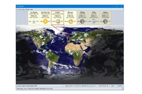
EarthTime 6.28.0
Download EarthTime for Windows

Exploring EarthTime: A Revolutionary Way to Visualize Our Planet
In an age where data is king, the way we interpret and visualize information is crucial. Enter EarthTime, an innovative platform that transforms complex data into compelling visual stories about our planet. Whether you are an environmental enthusiast, a policy maker, or simply curious about global trends, EarthTime offers a unique lens through which to understand the world.
What is EarthTime?
EarthTime is a cutting-edge tool developed by Carnegie Mellon University’s CREATE Lab. It harnesses the power of satellite imagery and global data to create dynamic, interactive maps that tell the story of our planet over time. By combining high-resolution images with comprehensive datasets, EarthTime allows users to visualize changes in the environment, demographics, and more, across various time scales.
Why EarthTime Matters
- Visualizing Change: One of the most compelling features of EarthTime is its ability to showcase changes over time. From deforestation in the Amazon to urban expansion in megacities, EarthTime provides a visual narrative that highlights both progress and challenges. This temporal perspective is invaluable for understanding the impact of human actions on the environment.
- Data-Driven Decisions: For policymakers and researchers, EarthTime serves as a vital tool for making informed decisions. The platform integrates data from reputable sources such as NASA, the World Bank, and UNESCO, allowing users to explore diverse topics like climate change, population growth, and economic development.
- Educational Impact: EarthTime is not just for experts; it’s also a powerful educational resource. Teachers and students can use the platform to explore global issues interactively, fostering a deeper understanding of complex topics. By engaging with visual data, learners can grasp the interconnectedness of global systems and the importance of sustainable practices.
Features of EarthTime
- Interactive Maps: Users can explore a wide range of topics through interactive maps that can be zoomed in or out to focus on specific regions or view global patterns.
- Time Lapse Visualization: EarthTime’s time-lapse feature allows users to watch the transformation of landscapes and urban areas over decades, providing a cinematic view of change.
- Storytelling Mode: EarthTime offers pre-made stories that guide users through specific themes, such as climate change or migration, using curated datasets and visualizations.
How to Use EarthTime
Getting started with EarthTime is simple. Visit the EarthTime website and explore the various themes available. You can select different datasets to overlay on the map, adjust the time scale, and even create your own stories by combining data points of interest. Whether you’re looking to conduct research or simply explore, EarthTime makes it easy to dive into the data.
Conclusion
EarthTime is more than just a tool; it’s a window into the dynamic processes that shape our world. By transforming data into visual narratives, EarthTime empowers us to see the big picture and understand the intricate tapestry of global change. As we continue to face environmental and social challenges, tools like EarthTime will be essential in guiding us toward a more sustainable future. Explore EarthTime today and witness the story of our planet unfold before your eyes.
Title: EarthTime 6.28.0
File name: ETSetup.exe
File size: 5.76 MB
Supported OS: All Windows Versions
Languages: Multiple languages
License: Trial
Date added: January 17, 2025
Author: DeskSoft
Website: www.desksoft.com
Category: Windows Apps, Desktop Enhancements, Other Desktop Enhancementsy.
Version 6.28.0(17.01.25)
- New: important updates of timezone and city databases
- Fix: various small changes and fixes
Version 6.27.8(07.01.25)
- New: updated city database
- Fix: various small changes and fixes
Version 6.27.7(18.12.24)
- New: updated city database
- Fix: various small changes and fixes


